Proposed Revisions to the EO Relationship to Standard grid in Biotics 5
In Biotics, EO crosswalks are stored in the “Relationship to Standard” grid; see screenshots below from Biotics5. Based on changes requested in 2006, we are proposing to modify the Relationship to Standard grid structure to improve documentation of EO crosswalks, particularly for EOs crosswalked to more than one type.
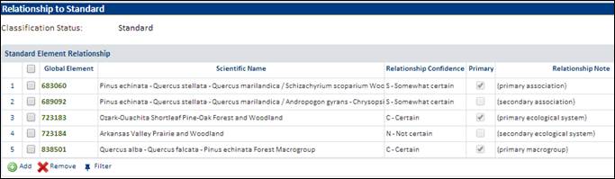
Current Structure of Relationship to Standard Grid
The current structure permits an EO to be crosswalked to more than one standard type in the same or different classifications and classification levels[1]; the rows in the grid list the type(s) to which the EO has been crosswalked. For example, as illustrated in the screenshot below, a single EO could be crosswalked to 2 associations, plus 2 systems, plus 1 macrogroup. There is a “Primary” checkbox to note that an EO is primarily a single standard type within a given classification level. There is also a field, Relationship Confidence, for indicating the confidence in the crosswalk of the EO to a particular type, and a Relationship Note field. Currently, there is no other field for documenting nuances of multiple crosswalks to a single EO. In addition, there is no easy way to see the classification level of a crosswalked type.
Relationship to Standard grid in Biotics 5:
Summary of Proposed Revisions
1) Remove “Primary” field
2) Add a “Percent of EO” field to record the percentage of the EO’s area that is assigned to a given type
3) Add a read-only field, either ELCODE or “Classification Level”, so users can readily see which classification level is in use for a given crosswalk. (Elcode contains classification-level information for ecological elements: CEGL for associations, CES for systems, G for groups, M for macrogroups, etc.)
4) Add custom fields for programs’ use to track any other related information they wish (e.g., to indicate the best EOs of a given standard type)
The proposed changes are shown in screen mockups below. Proposed revised fields are highlighted in yellow. Two examples are shown to illustrate the two options for revision #3: the first illustrates the use of the “Elcode” field to indicate the classification level, the second illustrates the use of “Classification Level”. Despite what is shown in these mockups, the fields Custom1 - 4 likely wouldn’t fit in the grid in B5; instead, they’d only display in the detail window when a row is selected.
Proposed revised grid with Elcode indicating classification level:
|
Global Element |
Elcode |
Scientific Name |
Confidence |
Percent of EO |
Note |
Custom1 |
Custom2 |
Custom3 |
Custom4 |
|
683060 |
CEGL002393 |
Pinus echinata - Quercus stellata - Quercus marilandica
/ Schizachyrium scoparium Wo |
S – Somewhat Certain |
80 |
|
|
|
|
|
|
689092 |
CEGL004447 |
Pinus
echinata - Quercus stellata - Quercus marilandica / Andropogon gyrans - Chrysop |
S –
Somewhat Certain |
20 |
|
|
|
|
|
|
723183 |
CES202.313 |
Ozark-Ouachita Shortleaf Pine-Oak Forest
and Woodland |
C – Certain |
100 |
|
|
|
|
|
|
723184 |
CES202.312 |
Arkansas Valley Prairie and Woodland |
N – Not
Certain |
100 |
|
|
|
|
|
|
838501 |
M016 |
Quercus alba - Quercus falcata - Pinus
echinata Forest Macrogroup |
C – Certain |
100 |
|
|
|
|
|
Proposed revised grid with Classification Level:
|
Global Element |
Scientific Name |
Classif. Level |
Confidence |
Percent of EO |
Note |
Custom1 |
Custom2 |
Custom3 |
Custom4 |
|
683060 |
Pinus
echinata - Quercus stellata - Quercus marilandica / Schizachyrium scoparium
Wo |
Association |
S –
Somewhat Certain |
80 |
|
|
|
|
|
|
689092 |
Pinus
echinata - Quercus stellata - Quercus marilandica / Andropogon gyrans - Chrysop |
Association |
S –
Somewhat Certain |
20 |
|
|
|
|
|
|
723183 |
Ozark-Ouachita Shortleaf Pine-Oak Forest
and Woodland |
System |
C – Certain |
60 |
|
|
|
|
|
|
723184 |
Arkansas Valley Prairie and Woodland |
System |
N – Not
Certain |
40 |
|
|
|
|
|
|
838501 |
Quercus alba - Quercus falcata - Pinus
echinata Forest Macrogroup |
Macrogroup |
C – Certain |
100 |
|
|
|
|
|
Intended Usage of the Relationship to Standard Grid
1) The ability to crosswalk an EO to more than 1 standard type of a given classification level is strictly intended to document the standard classification type(s) known with a relatively high level of confidence to be represented in the EO. It is NOT intended for listing every possible type that the EO might crosswalk to. Where an EO is crosswalked to more than one type within a given classification level, it is based on a conceptual spatial division of the EO, where different areas of the EO reflect the different types to which it is crosswalked (actual spatial divisions of the EO polygon would still need to be manually conducted, if desired).
2) The "Percent of EO" field is intended to document the percentage of the spatial extent of the EO representing each listed standard type. At a given classification level, the full extent of an EO could be a single type (i.e., 100% of it), or it could contain two types (e.g., with a 60%/40% split), or even three or more types (e.g., with an 80%/15%/5% split). If no percentage is entered, it will be assumed that all listed types of a given classification level occupy approximately equal area in the EO. The percentage is NOT intended to document the confidence in your assignment of a type to the EO.
3) Use "Relationship Confidence" to indicate your level of certainty that a given portion of the EO is correctly crosswalked to a particular standard type. If you're not sure which type a particular portion of the EO should be crosswalked to, enter the most likely type in the grid and record the other possible types in the "Relationship Notes" field. Do NOT enter the other possible types in new rows. Adding a row to the list of types to which a particular EO is crosswalked means that you are sufficiently confident in that type’s presence within the EO that you deem it worthy of including in any summary aggregations of EOs documented for standard types.
Rationale for Replacing "Primary" with "Percent of EO"
The “Primary” field was to allow EOs with multiple crosswalks to have a primary type flagged to facilitate summary aggregations of EOs documented for each standard type for any level of the classification. (EO aggregations can include counts of EOs by standard type, generating lists of standard types present in a geography based on EOs, maps of standard types generated via EO aggregations, etc.) However, choosing a primary type can be misleading because there is frequently a genuine one-to-many relationship between EOs and associations; for example, an EO might have a 60/40 or 50/50 split between a pair of associations. Where the EO is mostly one type (e.g., 95/5 or 99/1), the type covering only 5% or 1% of the EO is generally not worth recording.
The "Percent of EO" field would provide a clearer representation of the crosswalk relationships and provide more accurate reporting of EOs by standard type. When creating summary aggregations of EOs by classification unit, every standard type listed for the EO would be counted (subject to filtering by Relationship Confidence). EOs that are crosswalked to more than one type within a single classification level are consequently “virtually split” by the standard classification types to which they have been crosswalked. The "Percent of EO" field could be used to estimate the observed area and representational accuracy for each “virtual sub-EO”. The EO representation in GIS would remain the same; it would simply have multiple standard types attributed to its existing boundary, and the spatial precision would be lower.
If EOs that contain more than one standard type (at a given classification level) were reported as only one type using Primary Indicator, the number of occurrences for some types could be seriously underestimated. For example, if Association X tended to occur in smaller patches than the related Association Y, it might well appear that you had no occurrences of the smaller Association X, even though in reality you might have just as many EOs of Association X as of the related Association Y.